


Basics
- Length:
- 11.5 miles (18 km)
Description
The Rendezvous Backway procures its name from its array ofrendezvous-related historical sites that recall the days when furtrappers, Native Americans, and other traders met to barter.
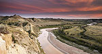
Stuffed in the extreme northeast corner of the state, the backwaybegins one mile east of Walhalla and meanders west along thePembina River. The river, which has carved the dramatic PembinaGorge, is the only white-water river in the state and is superb forcanoeing.
One of the deepest and steepest river valleys in North Dakota, thePembina Gorge is covered in 450 miles of state-groomed snowmobilingand hiking trails. In fact, the trail system was developed by theNortheast Snowmobile Club Association, which also sponsors theannual 'Snowfest' ride.
This area has been known as the 'Moose Capital of North Dakota'because some of the state's best moose and elk hunting is in thisvirtually unexplored wilderness.

