North Dakota Map

Facebook Twitter Google+
Follow The Go Travel Sites on Facebook

  • Places To Go

    A summary of what Minot has to offer.

    Summary list of destinations near Minot.

    Explore travel information for North Dakota cities, towns, parks, regions and more.

    Coverage for every state in the United States.

    Explore neighboring countries (and soon countries throughout the world).

    Theodore Roosevelt NP

    Rugged, often barren but always dramatic, North Dakota's badlands won over President Roosevelt in the late 19th century and continue to woo nature enthusiasts now as part of Theodore Roosevelt National Park.

  • Things To Do

    Searchable list of Minot tour companies, guides and outfitters, rental companies and more.

    Full information on Minot Tourist Attractions, Scenic Drives and other easy vacation activities…

    Detailed information on active pursuits in Minot such as biking, hiking, golfing and much more.

    Searchable lists of Minot museums, parks, galleries, and more.

    Introduction to all the things to do in North Dakota.

    Searchable list of tour companies, guides and outfitters, rental companies and more.

    Full information on Tourist Attractions, Scenic Drives, Sightseeing Tours and easy vacation activities..

    Detailed information on active pursuits such as biking, hiking, golfing and much more.

    Museums, parks, galleries, zoos, and everything else you could want to do in North Dakota.

    Things To Do

    Explore the state's Native American heritage and the history of Westward expansion in Bismarck en route to this state's bold and beautiful national park.

    Learn More
  • Sleep + Eat

    Searchable listings of Minot hotels, motels, resorts, bed & breakfast, and more.

    Searchable listings of Minot RV parks and campgrounds.

    Searchable listings of North Dakota hotels, motels, resorts, bed & breakfast, and more.

    Searchable listings of North Dakota RV parks and campgrounds.

    Lodging and Hotels

    Use our easy Lodging Search to find exactly the type of accommodation you are looking for at the right price.

    Search Now
  • Travel Planning

    Transportation companies, driving directions and more for Minot.

    Minot weather report, historic temperatures and climate info,…

    Searchable lists of Minot tourism offices and other helpful government agencies.

    Explore destinations near Minot.

    Request Free Travel brochures from destinations throughout North Dakota.

    Transportation companies, airports and interactive maps for North Dakota.

    Travel and tourism books and maps for North Dakota.

    Basic facts about North Dakota, including a guide to every city and town in North Dakota.

    Searchable lists of North Dakota tourism offices and other helpful government agencies.

  • Photo Gallery

    Searchable slide shows of North Dakota photos.

    Searchable slide shows of North Dakota videos.

    Searchable slide shows of Minot photos.

    Photo and Video Gallery

    Browse photos and videos from across the state, take a virtual tour, search for the imagery you want to see.

    View Now
  • Map It!

Des Lacs National Wildlife Refuge Backway

No Media or Maps Available
If you are the owner/manager of this business and would like to improve your listing, please submit a request.
Basics
Length:
19 miles (30 km)

Description

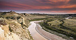
The Des Lacs National Wildlife Refuge Backway, found in the north-west corner of North Dakota, provides excellent opportunities to view the rolling hills and wooded draws of the Des Lacs Valley. The most striking experience this backway offers is the excellent wildlife viewing opportunities found at the refuge. Over 250 species of birds have been seen there and include waterfowl, raptors,and many other migratory birds. Deer, moose, and other wildlife are also seen along this route.

Points of Interest Along The Way

Des Lacs National Wildlife Refuge Visitor Center (ND)

The visitor center at Des Lacs National Wildlife Refuge Headquarters features displays of local history and native wildlife. For example, photographs of E.S. Gross and mounts of wildlife commonly found in the area can be found in the visitor center.

Directions

To get to the visitor center, head north on US Highway 52. In Kenmare, turn left (west) on County Road 2. At the intersection of County Road 2 and County Road 1, the visitor center is on the south side.

Historic Danish Mill (ND)

The Danish Mill was built in 1902 on a homestead eleven miles north of Kenmare. Area farmers ground grains into flour here. In 1959, the mill was moved into the city of Kenmare and its restoration was completed in 1961. In 1965 the mill was moved to the Park on the Square and given a face lift in 1996. The Park on the Square has beautiful trees, flowers, and benches on which to enjoy a summer's day. The Danish Mill is located in the center of the park, which the city of Kenmare was built around.

Directions

To get to Historic Danish Mill from Des Lacs Byway, head north US Highway 52 to the city of Kenmare, six miles north of the byway. Historic Danish Mill is located in The Park on the Square, in the middle of the city.

Lake County Museum (ND)

The Lake County Historical Society Museum preserves the history of the area in a five-acre, eighteen-building village. Of special interest is a pioneer church, a one room schoolhouse, a home built in 1904, and many early day businesses -- each furnished to recreate their original settings. Young and old alike enjoy touring the village; for some it offers a glimpse of their ancestors' lives, for others, a chance to reminisce about the days of their youth.

Munch's Coulee Hiking Trail (ND)

From Munch's Coulee Hiking Trail you have excellent bird watching opportunities. The trail climbs up the side of the draw to the upland prarie. The upland portion is one of the best places on the refuge to view native wildflowers as well as upland birds. The upland portion of the trail, as it returns to the parking area, allows hikers a spectacular view of Lower Des Lacs Lake and marsh as well as the route of Des Lacs Scenic Backway. The bottom portion of the trail is hard surfaced and is universally accessible. Four benches provide resting areas along the entire trail.

Taskers Coulee Picnic Area (ND)

Taskers Coulee lies in a heavily wooded coulee south of the Des Lacs refuge headquarters and can be reached via Des Lacs Scenic Backway. This lighted area offers a covered shelter, picnic tables, grills, drinking water, and restrooms. There are activities for all ages, including playground equipment, a sand volleyball court, a baseball diamond, and numerous hiking trails.

Length:
19 miles (30 km)
Main Roads:
US-52 W
Customizable Directions

Formatted DirectionsMap
North Dakota Minot AmericasBestValueInn-Skyscraper-2012-ValueClub-ND

Email Page Link

Complete the form below to email this page to a friend or family member's email. You can send yourself an email as well. Your email and your recipient's email will NOT be shared with anyone. See our full Privacy Policy for details.
:
:
:


:
Copy Yourself on the Email Yes No
:
: